Digital Collection System
Mission Analysis Planning Suite™
New Item - Purchase DCS-MAPS 2021
DCS-MAPS 2021
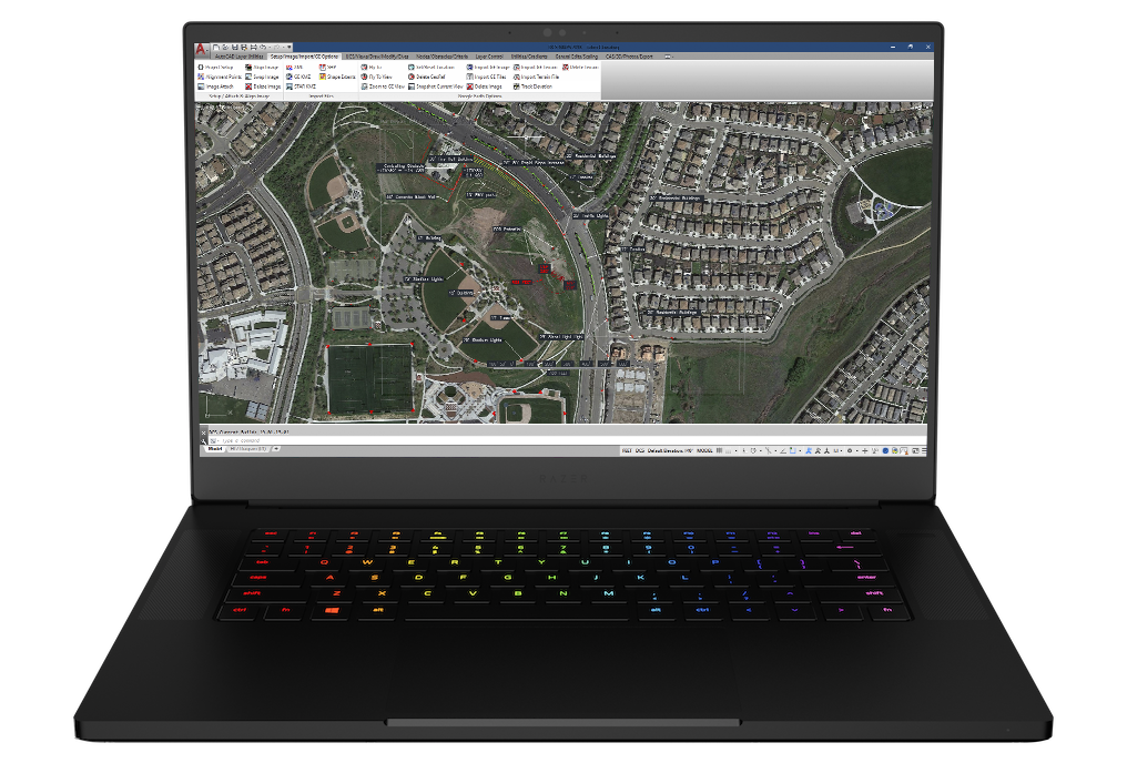
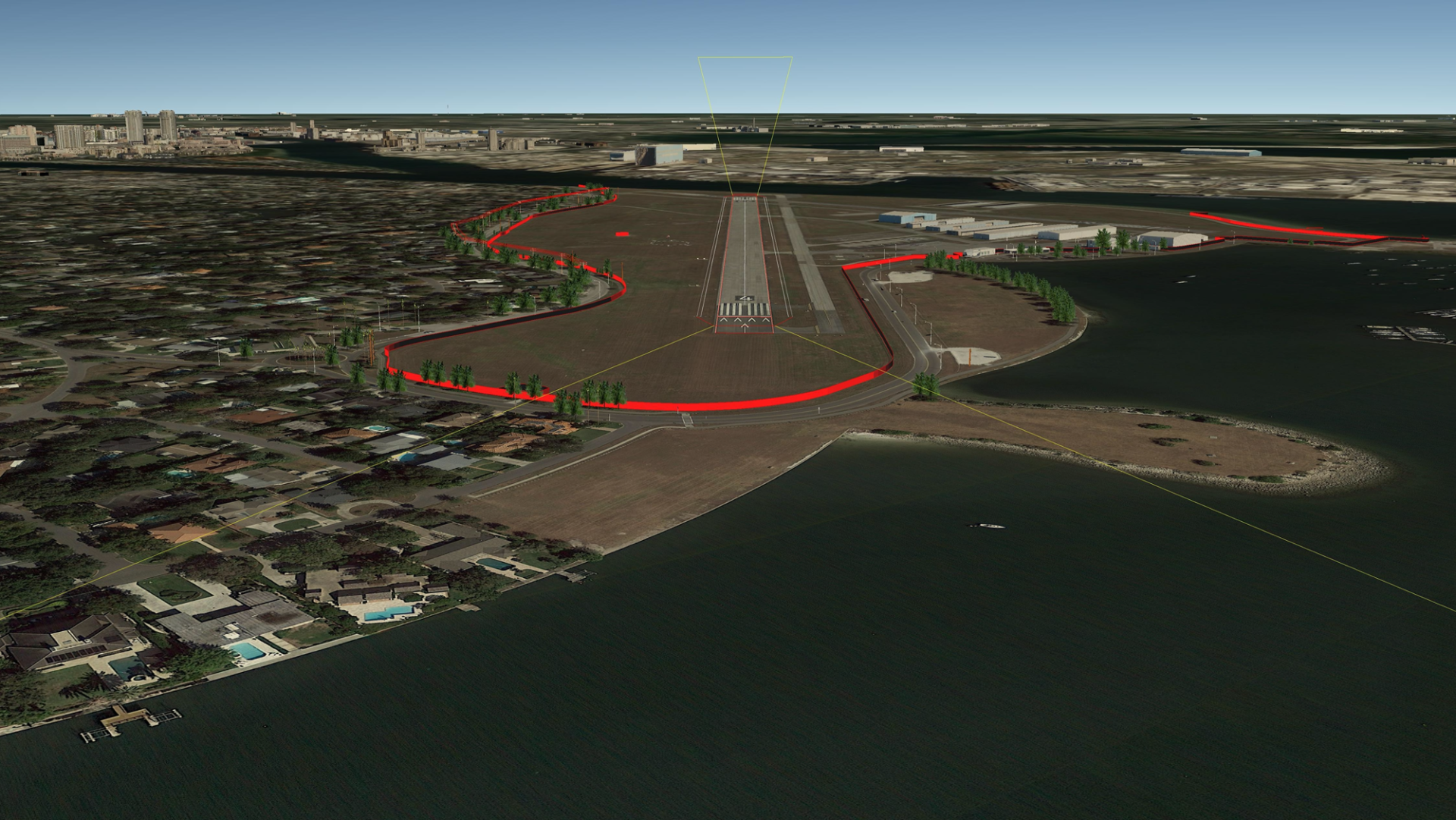
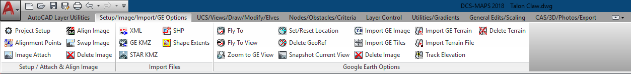
Digital Collections System & Mission Analysis Planning Suite (DCS-MAPS) – The definitive AutoCAD Original Equipment Manufacturers (OEM) solution for Airfield & Assault Zone Survey production for commercial and government industries. This software application is specifically designed with the airfield & assault zone surveyor in mind. DCS-MAPS assists surveyors in pre-mission planning by allowing the surveyors to get feel for the environment they are about to enter and plan their mission accordingly. After data collection, surveyors can easily import their data to quickly analyze and ensure the site meets aircraft minimum criteria and safety requirements. Upon completion of survey, the DCS-MAPS export feature enables surveyors to easily produce multiple highly accurate and professional looking products depicting all applicable geospatial data about the site and its surroundings, as well as display obstacles & hazards to the aircraft, aircrews, and groundcrews in easy to understand formats & file types. DCS-MAPS survey products are designed to integrate with Talon Point, and can be submitted with ease for quality control, safety of flight review, and final approval. DCS-MAPS is the most highly effective and accurate application for creating airfield & assault zone surveys.
Features:
New Look & Feel – DCS-MAPS 2021 and all the specialized command ribbons have a fresh new look & feel with a touch of familiarity in the icons. The dark theme now has a modern dark blue interface that’s easy on the eyes. The new dark theme offers contrast improvements and sharper appearance of icons.
Quickly Measure Feature – DCS-MAPS 2021, measuring distances is faster than ever with the new Quick Measure tool, which measures 2D drawings simply by hovering your mouse. Dimensions, distances, and angles are dynamically displayed as you move your mouse over and between objects.
New Blocks Palette – The new Blocks palette makes it easier to insert blocks with visual galleries and the ability to filter for the exact block you’re looking for. You can simply drag and drop blocks into the drawing from Current Drawing, Recent, or Other Drawing tabs.
New Purge Feature – Removes multiple unneeded objects at once with easy selection and a visual preview area.
Drawing Revisions Comparison – Allows User to compare two versions of a drawing using a quick toggle without leaving your current window and import desired changes into the current drawing in real time.
Under the Hood Performance Upgrades:
Geospatial Precision & Calculation Enhancements
Software Performance Improvements
Software Security Enhancements
World Magnetic Model (WMM) Forward & Backward Compatibility
Streamlined Imagery Import
Advance Feature Upgrades:
Convert from 2D to 3D
3D Export to KMZ
Free-flow Image Import
Image Tiling Import
Enhanced GE Terrain Import
GRG & 9-Line Creation Tools
New Analytic Utilities
Download DCS-MAPS Update (20.10.02.01)
UPDATE 20.10.02.01:
This update is only for DCS-MAPS 2020 owners.
This update addresses an issue when a user selects “Project Overruns Outward” vs. the default “Project Overruns Inward.” The update corrects the calculations and where the coordinates are populated within the latest versions of the LZ & LTFW Formsection I. PENETRATIONS – EOU & Displaced Threshold Coordinates. If you run into any issues, please do not hesitate to contact us!
Easy-to-Use Tools
Designed for the warrior and surveyor in mind, DCS MAPS™ is easy to use and allows you to create Professional products.
Familiar Design
DCS MAPS™ features are powerful and makes it user friendly and familiar for even a novice.
Utilize Google Earth Snippets
DCS MAPS™ supports import of Google Earth snippets/screenshots for easy calculations and adjustments. Using field collected data and measurements provided by Survey Apps from iOS, Android, or Trimble equipment to gather, produce,

Customizable Courses Available
With each purchase of DCS MAPS™ we recommend attending one of entry level training courses to provide you with the skills and know-how to best utilize the program and become a proficient surveyor in no time.
Expandable menus and numerous options allow unlimited customization and modifications to optimize the toolbar layout
DCS MAPS is Quick, Simple, Easy, and Powerful.
Digital Collection Systems (DCS)™ is the definitive AutoCAD Original Equipment Manufacturers (OEM) solution for Airfield & Assault Zone Survey production for commercial and government industries.
Learn about AUtoCAD software here: AutoCAD AutoDesk
![]() DCS MAPS™, is powered by Ingersoll Consulting, Inc.
DCS MAPS™, is powered by Ingersoll Consulting, Inc.